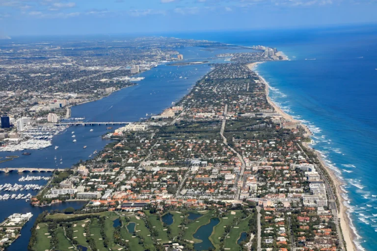
Riviera Beach is a city in Palm Beach County, Florida, on the Atlantic coast and the Intracoastal Waterway, and three things shape most purchases there: flood and coastal rules, a working Port of Palm Beach waterfront, and city property tax and redevelopment decisions.
This guide covers the geography, waterfront, flood and hurricane rules, property taxes, permits and school lookup that apply when you buy or sell a home in Riviera Beach. Each rule links to the city, county, state or federal office that publishes it.
What kind of place is Riviera Beach, Florida?
Riviera Beach is a coastal city with 8.278 square miles of land and 1.377 square miles of water, according to the Census Bureau 2020 Gazetteer file for Florida places. The city’s own history page says it sits “along the Atlantic shores of southeast Florida in Palm Beach County,” reports “a population of more than 30,000 residents,” and notes that the Port of Palm Beach is “located right in Riviera Beach.”
| Key fact | What the official source says |
|---|---|
| County | Palm Beach County |
| Land area | 8.278 square miles (Census 2020 Gazetteer) |
| Water area | 1.377 square miles (Census 2020 Gazetteer) |
| Residents | More than 30,000, per the city’s history page |
| Municipal code on the Property Appraiser’s taxing list | 56 |
| School district | The School District of Palm Beach County |
| Working waterfront | Port of Palm Beach, with cargo operations and a cruise terminal |
| County airport | In West Palm Beach, operated by the Palm Beach County Department of Airports |
The city lists a Mayor’s Office, City Council and City Manager’s Office on its official site. Development Services handles planning, zoning, building and code compliance.
Which beaches, waterways and parks define Riviera Beach?
Riviera Beach has ocean beach, Intracoastal frontage and an island park, and the county publishes the details for each.
- Ocean Reef Park: the county page lists 13.68 acres, 700 feet of guarded beach frontage, a dune ecosystem overlook and sunrise-to-sunset hours.
- Phil Foster Park: the county page lists 17.92 acres beside the Blue Heron Boulevard bridge, 1,000 feet of Intracoastal frontage, boat ramps, and a limestone and reef-module snorkel trail over two acres in 6 to 10 feet of water.
- Peanut Island Park: the county page lists 37.44 acres near the Lake Worth Inlet, “boat access only,” independently operated water taxis, and 17 reserved tent sites.
- City parks: the city’s Parks and Recreation page lists The Municipal Beach, Congress Lakes Park, Lone Pine Park and Goodmark Park, among others.
The Lake Worth Inlet is one of two ocean inlets into the lagoon. Palm Beach County’s Lake Worth Lagoon page describes the lagoon as spanning 20 miles from North Palm Beach to Ocean Ridge. For a waterfront parcel, confirm which waterway the lot fronts, whether it has a seawall or dock, and what permits the city requires for work on either.
The county pages for Ocean Reef, Phil Foster and Peanut Island parks each state that balloons are prohibited, and the city’s code page links to Palm Beach County’s sea turtle codes. If a home is near the beach, ask what lighting and balloon rules apply.
Does the Port of Palm Beach change what living near the waterfront is like?
Yes, because the Port is an active cargo and cruise facility inside the city, and its operations are part of the working waterfront. The Port’s own site says about 80% of its cargo has historically been outbound, describes granite and cement imports, and reports plans to expand cruise facilities.
When LPE Realty reviews a Riviera Beach purchase near the water, we compare the parcel against the city’s Zoning and Future Land Use Map before anything else, so the buyer knows whether the neighbors are residential, marine, commercial or industrial.
The city’s Community Redevelopment Agency says a transformation of the Riviera Beach Marina is underway as a public-private partnership, and lists Marina Village, a Broadway corridor project, an Avenue E streetscape and a CRA boundary expansion. Check those project pages for any parcel near them.
How do flood zones, hurricane zones and coastal rules work in Riviera Beach?
Flood zones come from FEMA maps, and hurricane evacuation zones come from the state’s lookup tool. They are two separate lookups and both matter.
- FEMA flood maps: FEMA names the Flood Map Service Center as the official place to find flood hazard maps, and says any place with a 1% or higher chance of flooding each year is high risk.
- City flood help: the city’s Flood Hazard Information page says the city provides map determinations that show whether federal law requires flood insurance, and points residents to county GIS flood layers.
- Floodplain manager: the city’s Building page says the Building Official is also the Floodplain Manager.
- Evacuation zone: the state’s Know Your Zone page says to type in your address, and that zones are lettered and the most vulnerable zone is generally evacuated first.
Renovation matters too. FEMA’s substantial improvement definition covers an improvement that costs 50 percent or more of the structure’s market value, so ask the city’s Floodplain Manager how that test applies before planning a large renovation. The city’s Building page also says its small-job permit exemption “does not apply in a flood hazard area.”
When LPE Realty reviews a Riviera Beach purchase, the first document we pull is the parcel’s flood zone, because it drives insurance and renovation options. Our guides on windstorm and flood insurance due diligence and home insurance when buying explain the next steps.
How are Riviera Beach property taxes figured, and when are they due?
A bill is the taxable value divided by 1,000 and multiplied by each taxing authority’s millage rate, per the Property Appraiser’s glossary. The city’s rate appears on the Property Appraiser’s Tax Rates and Contact Info page:
| Riviera Beach millage | 2025 final | 2026 roll-back | 2026 proposed |
|---|---|---|---|
| Operating | 8.3500 | 8.0181 | 8.3500 |
| Debt service | 0.0000 | 1.0000 | 1.0000 |
The same page labels the 2026 figures “Proposed,” so confirm the final rate on the actual 2026 bill. The city’s rate is only one line on a bill. The Property Appraiser’s taxing authority list also names the school district, the county, the Port of Palm Beach and other districts, and does not say which apply to a given parcel, so read the parcel’s own notice.
The Tax Collector says taxes are payable November 1 to March 31, with a 4% discount in November, and delinquency starting April 1. The Property Appraiser says homestead applications are due by March 1, title must be held as of January 1, and the exemption does not transfer automatically to a new home. LPE Realty also walks buyers through those dates in our guides to filing homestead in Palm Beach County and property taxes after you buy.
What do city permits, zoning and rentals mean for a buyer?
The city runs permits through an online portal, and its Building page says not every permit type can be submitted online, that a single-family permit expires one year after issuance or when the next Florida Building Code edition takes effect, whichever is later, and that exempt work must still meet zoning, floodplain, drainage, easement and setback rules.
- Comprehensive Plan: the city’s Comprehensive Plan page lists Future Land Use, Housing and Coastal Management elements, and the Riviera 2040 update lists goals including coastal resiliency, workforce and affordable housing, and zoning changes.
- Live Local Act: the city’s Live Local Act page says qualifying affordable projects in commercial, industrial and mixed-use areas are approved administratively, with rental projects needing at least 40% of units affordable for 30 years.
- Rentals: the city’s Business Tax page lists a Residential Rental Application and a Rental Renewal Affidavit but does not describe the rules, so ask the city before buying a home to rent.
For condominiums, the state rules on inspections and reserves matter as much as city rules. See our guides to buying a condo in Florida and milestone inspections and SIRS.
How do I find assigned schools and get around Riviera Beach?
The School District of Palm Beach County links a Find My School tool from its home page. Check it against the specific home address, or confirm the assignment with the district, rather than relying on a neighborhood name. For transit, Palm Tran lists 29 routes and about 2,700 stops across the county, so check its route map against a specific address. The county’s commercial airport is in West Palm Beach, operated by the Palm Beach County Department of Airports.
Frequently asked questions
What is the Riviera Beach city millage rate?
The Property Appraiser lists Riviera Beach operating millage at 8.3500 for 2025 final and 8.3500 proposed for 2026, plus a 1.0000 debt service rate proposed for 2026. Confirm the final figure on your tax bill.
Can I drive to Peanut Island?
No. Palm Beach County lists Peanut Island Park as boat access only, and says water taxis are independently operated.
How do I find my hurricane evacuation zone?
Use the state’s Know Your Zone map and type in the address. Zones are lettered, and the most vulnerable zone is generally evacuated first.
When do I apply for homestead exemption after buying?
Applications are due by March 1 of the year the benefit applies, and title must be held as of January 1. The exemption does not transfer automatically from a previous home.
Does the city regulate rentals?
The city’s Business Tax page lists a Residential Rental Application and a Rental Renewal Affidavit. Call the city for the rules before you buy a home you plan to rent.
If you are weighing a move here, buy with LPE Realty or sell with LPE Realty. LPE Realty LLC is a licensed Florida real estate brokerage.